• Skip to main content
  • Skip to primary sidebar
  • Skip to footer

LIRPC

  • About
    • Resources
      • Reports
      • News
        • In the News
        • Calendar of Events
      • Meetings
      • Key Links
      • Suffolk County Economic Development Corporation
    • Mission
    • Chairman’s Letter
    • Who We Are
    • Projects of Regional Significance
    • Connect
  • Our Work
    • Economic Development
    • Energy
    • Environment
    • Equity
    • Housing
    • Taxation
    • Transportation
    • Long Island 2035
  • LINAP
    • Background & Scope
    • Initiatives
      • Long Island Water Quality Challenge (LIWQC)
      • Nitrogen Smart Communities
      • Hempstead Bay Water Quality Monitoring Program
      • Sustainable Landscaping Resource Hub
      • Fertilizer Management
      • Nutrient Bioextraction Initiative
      • Reduce Nitrogen Pledge
      • Subwatersheds Wastewater Plans
      • Suffolk County Wastewater Management District Feasibility Study
      • Water Reuse
    • Partners & Initiatives
    • LINAP Newsletters
  • Nitrogen Smart Communities
  • LI Garden Rewards Program
  • Economic Flood Risk Study
You are here: Home / Environment / Long Island’s Waterfront Zoning and Uses GIS Inventory

Long Island’s Waterfront Zoning and Uses GIS Inventory

Long Island’s First Waterfront Zoning and Uses GIS Inventory: A Research Database Providing Geographic Context to Regional and Local Planning on Long Island

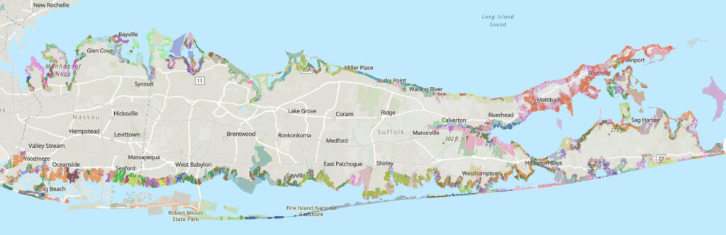
The Long Island Regional Planning Council has partnered with LiRo GIS to create a comprehensive inventory of waterfront zoning and uses on Long Island. The objective was to develop a centralized geodatabase of zoning classifications and associated waterfront activities, including marinas and commercial fishing. The Inventory provides a never-before-available resource for exploring the complex mosaic of Long Island’s waterfront development at any scale from the regional to parcel level.

The study area encompassed parcels within a quarter-mile buffer from the coastline, spanning 79 local government jurisdictions in Nassau and Suffolk Counties jurisdictions across Nassau and Suffolk Counties including: 2 Cities, 13 Towns, and 64 Villages. These jurisdictions had various zoning categorizations, resulting in nearly 600 unique zoning designations. The collaboration between LIRPC and LiRo GIS has resulted in a valuable GIS-based database that can be applied in development, planning, or economic studies.

As a publicly available dataset, the Waterfront Zoning and Uses GIS Inventory is a tremendous resource that can be filtered, analyzed, presented, and shared transparently in dynamic ways. Data layers can be combined to bring new vantage points to old issues, cultivating the progression towards greater understanding.

Click here for the Waterfront Zoning and Uses GIS Inventory

Filed Under: Environment

Primary Sidebar

Footer

Contact

516-571-7613
516-571-7614

1864 Muttontown Road
Syosset, NY 11791
info@lirpc.org

STAY INFORMED

Enter your email address to receive email updates from the LIRPC:

Connect

Facebook Twitter LinkedIn

Copyright © 2025 Long Island Regional Planning Council